


Kuwait’s eponymous capital city is located on the Persian Gulf, and concentrates most of the country’s population, culture, economy and decision making. Like the rest of the Gulf, it is highly vulnerable to sea level rise, and it may have to work with its neighbors to fend off the swelling waters.
—
Though considered arable, the Kuwait inner ranges are quite inhospitable, and much of the country’s oil-based trade goes through maritime channels. It is considered a maritime and mercantile country, and is highly dependent on the coastal zone for its drinking water, fisheries, water cooling for power plants and recreation. In fact, the bulk of its urban, commercial and industrial infrastructure is located near the shoreline, as is 90% of its population.
Kuwait natural freshwater resources are very limited. It is an arid country, with high temperatures and evaporation rates, and low humidity and precipitation rates, with no surface water bodies. Desalination plants provide most of the drinking water, which is heavily subsidized, thus encouraging irresponsible usage and waste. The largest source of water for industrial and agricultural use is the groundwater reserve, which has been excessively pumped and whose quality is deteriorating. This is due to saltwater intrusion, and return of pumped up irrigation water with fertilizers and pesticides.
Near the northern shores of Kuwait is a small group of islands, the largest of which is called Bubiyan island. An uninhabited salt marsh, its lies very low and faces full submersion within the next few decades. It serves as an important rest area for migratory birds on the Turkey-India, and the Eurasia-Africa routes.
Earth.Org has modelled sea level rise from Kuwait City northward to illustrate the need for a rapid decarbonization.
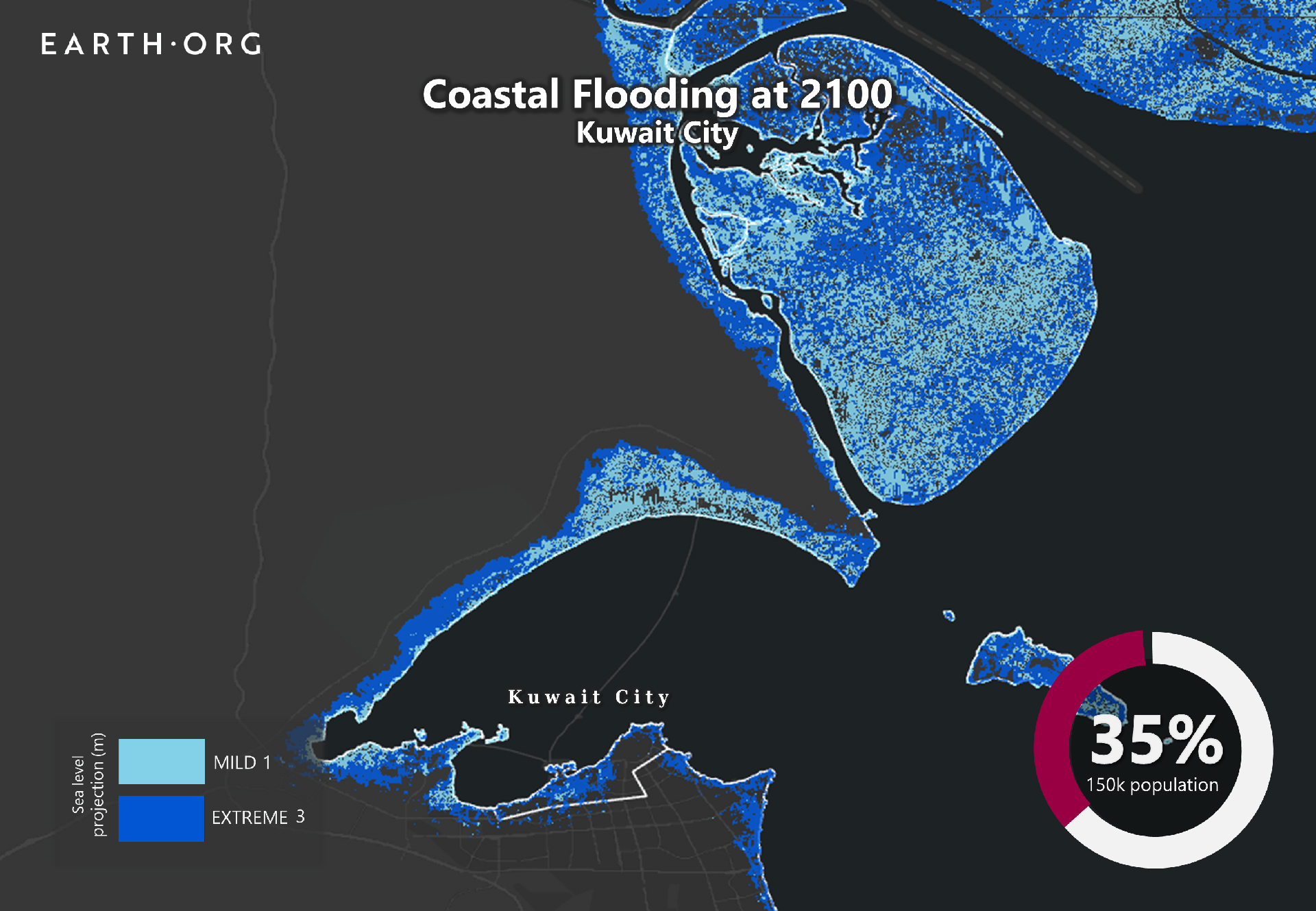
Sea level rise projections by 2100 for two scenarios with the amount of rise in meters indicated (mild = 1m; extreme = 3m). Population displacement indicated bottom right.
Sea Level Rise Methodology
Global mean sea level is projected to rise by 2m at the end of this century. However, in order to determine local sea level rise (SLR), one has to take into account local coastal flood levels which could be 2.8m above Mean Higher-High Water (MHHW) at extreme forecasts. These local levels bring variability to the projected SLR from 1m to 6.5m (eg. Rio vs Kolkata).
The SLR scenarios used in this study are based on the forecasts from Climate Central – Coastal Risk Screening Tool with the following parameters:
- Sea level Projection Source
- Coastal Flood Level
- Pollution Scenario
- Luck
Sea level Projection Source:
From two highly cited journals by Kopp et al., estimating SLR mainly due to ocean thermal expansion and ice melt. The mid-range scenario projected 0.5-1.2m of SLR based on different representative concentration pathways (RCP) defined by the IPCC. While the pessimistic scenario added more mechanisms of ice-sheet melting, estimating SLR at 1m-2.5m in 2100, with a projection of 10m SLR at 2300.
Coastal Flooding
More frequent coastal flooding is a direct impact of sea-level rise. Based on the Global tides and surge reanalysis by Muis et al., (2016), it is estimated that the extreme coastal water level could be from 0.2 – 2.8m over the mean level. While in extreme cases like China and the Netherlands it could experience 5-10m of extreme sea levels. Here, the coastal local flood level is added on top of the projected SLR.
Pollution Scenario:
Allows choosing the RCP, the greenhouse gas concentration trajectory defined by the IPCC. The mild level is based on RCP4.5, of 2°C temperature rise; while the Extreme level is based on RCP 8.5, of 4°C temperature rise.
Luck:
Applies to the baseline SLR, defined in the “Sea level projection” section, upon which we add flooding. “Mild” refers to the mid-range scenario of 0.5-1.2m, and “extreme” to the pessimistic scenario of 1-2.5m. We used the high-end value of each scenario (mild = 1m; extreme = 2.5m).
You might also like: Sea Level Rise by 2100 – The Persian Gulf
References:
-
Kulp, Scott A., and Benjamin H. Strauss. “New elevation data triple estimates of global vulnerability to sea-level rise and coastal flooding.” Nature communications 10.1 (2019): 1-12.
-
Florczyk, A. J., Corbane, C., Ehrlich, D., Freire, S., Kemper, T., Maffenini, L., Melchiorri, M., Politis, P., Schiavina, M., Sabo, F. & Zanchetta, L. (2019). GHSL Data Package 2019 Public Release.
-
Kopp, R. E., DeConto, R. M., Bader, D. A., Hay, C. C., Horton, R. M., Kulp, S., Oppenheimer, M., Pollard, D. & Strauss, B. H. (2017). Evolving Understanding of Antarctic Ice-Sheet Physics and Ambiguity in Probabilistic Sea-Level Projections. Earth’s Future, 5(12), 1217–1233.
-
Kopp, R. E., Horton, R. M., Little, C. M., Mitrovica, J. X., Oppenheimer, M., Rasmussen, D. J., Strauss, B. H. & Tebaldi, C. (2014). Probabilistic 21st and 22nd Century Sea-Level Projections at a Global Network of Tide-Gauge Sites. Earth’s Future, 2(8), 383–406.
-
Kulp, S. A. & Strauss, B. H. (2019). New Elevation Data Triple Estimates of Global Vulnerability to Sea-Level Rise and Coastal Flooding. Nature Communications, 10(1), 4844. Retrieved June 21, 2020, from http://www.nature.com/articles/s41467-019-12808-z
-
Muis, S., Verlaan, M., Winsemius, H. C., Aerts, J. C. J. H. & Ward, P. J. (2016). A Global Reanalysis of Storm Surges and Extreme Sea Levels. Nature Communications, 7.
-
AlAli, E. H. “Groundwater history and trends in Kuwait.” WIT Transactions on Ecology and the Environment 112 (2008): 153-164.
-
El Raey, Mohamed. “Impact of sea level rise on the Arab Region.” University of Alexandria. Arab Academy of Science, Technology, and Maritime (2010).
![The Statistics of Biodiversity Loss [2020 WWF Report]](https://u4d2z7k9.rocketcdn.me/wp-content/uploads/2020/12/lprwinkyTHB-544x306.jpg)


