Satellite data provides unprecedented information on the world we live in. Its global coverage and constant updates shed light on the interplay between humans and climate. A relatively novel application of satellite data is to track vector-borne disease spread, helping healthcare to be prepared and save more lives.
Earth.Org takes a closer look.
—
What is vector-borne disease?
- Disease that results from an infection transmitted to humans and other animals by blood-feeding arthropods, such as mosquitoes, ticks, and fleas
- Example: Rift Valley Fever. Cholera, Chikungunya
By studying weather conditions leading up to outbreaks of the afore-mentioned examples, specific patterns were observed. Since we now have an idea of the kind of weather that leads to disease spread, combining this with near-real time satellite information allows us to make informed decisions ahead of time. The more data we compile, the better we can model and predict our weather and the associated consequences.
Why does this matter?
Not much attention and resources have been put on neglected tropical disease like those mentioned above because they generally afflict the world’s poorest. Nonetheless, these illnesses are a huge burden on global health, affecting around a 6th of the world’s population at all times.
Some past examples
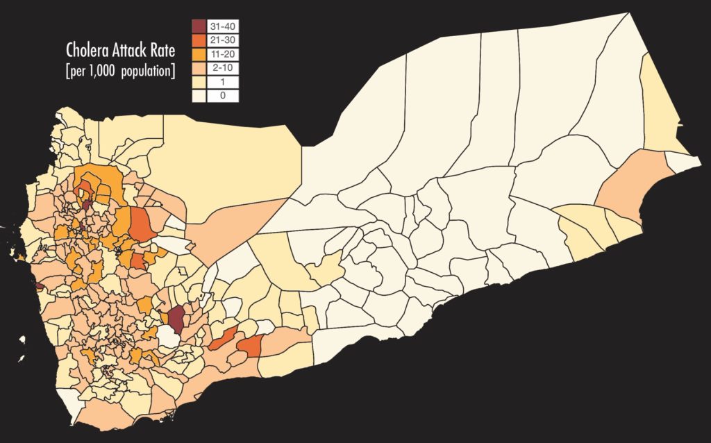
- Cholera Prediction Modeling System | Yemen, 2017
-
- Prediction model by hydrologist Antar Jutla and his team achieved an accuracy of 92% in predicting areas where cholera appeared in Yemen. It even predicted its occurrence in areas that are not usually susceptible to the disease.
- The dataset used is publicly available on NASA’s Sea-Viewing Wide Field-of-View Sensor (SeaWiFS)

Distribution of cholera cases in 2017 in Yemen. Results from Antar Jutla’s model (Source:https://www.nasa.gov/press-release/nasa-investment-in-cholera-forecasts-helps-save-lives-in-yemen)
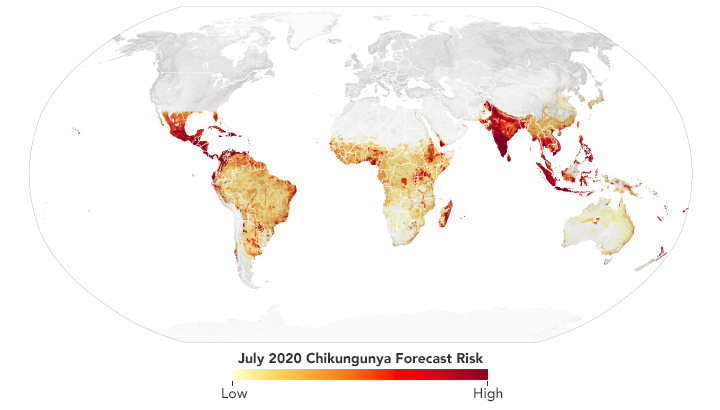
- Chikungunya Risk Mapping and Forecasting System (CHIKRisk) | Global
- The model provides monthly outlooks of where chikungunya risk is highest around the world.
- Datasets used:
- NASA’s Moderate Resolution Imaging Spectroradiometer (MODIS); NASA’s Global Land Data Assimilation System
- NASA’s Socioeconomic Data and Applications Center
- Walter Reed Biosystematics Unit’s VectorMap

A prediction map on the spread of chikungunya across the world in July 2020 (Source: https://vbd.usra.edu/).
The takeaway:
Advanced satellites have opened new doors for disease tracking and prevention. Ailments that were once too difficult to tackle can now be monitored remotely with fewer, but higher-quality resources. The effort to result ratio is now too attractive to be ignored, and we can finally address issues that have been hampering global well-being and development in less developed countries.
This article was written by Wing Ki Leung.
You might also like: Bushmeat Hunting in South America
References:
https://earthobservatory.nasa.gov/features/disease-vector
https://www.niaid.nih.gov/research/neglected-tropical-diseases


![The Statistics of Biodiversity Loss [2020 WWF Report]](https://u4d2z7k9.rocketcdn.me/wp-content/uploads/2020/12/lprwinkyTHB-544x306.jpg)


