


The summer of 2020 has seen the state of California among the largest and most severe wildfires in its history, recording over 4 million acres of forest burned this year, in almost 9000 incidences. In fact, 5 out of 6 of California’s largest wildfires in history occurred in 2020. While many of these fires have been brought under control, new hotspots have appeared in forests of the southern hemisphere, this time, as visualised by NASA’s Aqua Satellite, in Bolivia.
—
Using Moderate Resolution Imaging Spectroradiometer (MODIS) technology, NASA’s Aqua Satellite was able to capture images of the smoke plumes from the wildfires. Visualisation of hotspots was done by the heat signature picked up by the Visible Infrared Imaging Radiometer Suite (VIIRS), associating abnormally warm temperatures of a given area with the presence of a fire or a hotspot.
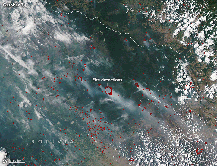
Images of wildfire distribution in Bolivia taken by NASA’s Aqua Satellite over 7-10 October 2020, showing fire hotspots in red across the dry forests of Bolivia, and the neighbouring Pantanal wetlands of Brazil. (Source: NASA Earth Observatory).
Seasonal fires in Bolivia are not a new occurrence. Small, controlled fires have been used to clear the land for agricultural uses, a traditional practice still used in some countries today. Alongside these, unchecked, illegal deforestation is rampant
Temperatures above 45°C in conjunction with drought, little rainfall and strong winds creates the “perfect” conditions for wildfire ignition and propagation. Thus, Bolivian officials have declared a state of emergency, but they are not the only ones whose forests are burning. Brazil is notoriously struggling with the Amazon’s increasing drought, and Argentina and Paraguay have also had ferocious flares this season.
A 20 to 40 year-long climatic cycle called the Atlantic Multi-Decadal Oscillation (AMO) created droughts in the 2000s that caused fires to burn for months. This year fits the same climatic profile and scientists believe the AMO is the main culprit behind this year’s fire intensity. However, the extent and range of today’s burning goes well past anything on record, be it the Pantanal’s fires or the 1.3 million acres lost in Bolivia.
Despite the severity of these fires, relief is likely to be delayed, as meteorological forecasts suggest continued high temperatures, winds and dry weather for the coming weeks.
This article was written by Javier Chai Rui Cheng.
![The Statistics of Biodiversity Loss [2020 WWF Report]](https://u4d2z7k9.rocketcdn.me/wp-content/uploads/2020/12/lprwinkyTHB-544x306.jpg)


