Satellite information is becoming an ever more ubiquitous tool to help us monitor and adapt to our rapidly changing world. As wildfires increase in intensity, scientists are looking to use satellite imagery to learn more about forest recovery after a blaze.
Since 1985, scientists have been able to observe and monitor the world’s surface and atmosphere thanks to satellite instruments. These can observe by day or night and see land through clouds, smoke and haze, giving us unprecedented levels of information on many natural and man-made processes.
Wildfires have been getting noticeably worse due to more intense droughts as climate change warms our planet. Satellites have allowed us to observe fire fronts and the subsequent burn scars from above, but now NASA researchers are going a step further. Landscape ecologist Naiara Pinto and her colleagues at the Jet Propulsion Laboratory intend to use satellite imagery to assess how well California’s ecosystems recover after fires.
Much like echolocation, we can observe ground topology using microwave pulses that bounce back to the source of emission – changes over time can then be detected with subsequent fly-bys, like those resulting from earthquakes, flooding, or denuded ground after large fires.

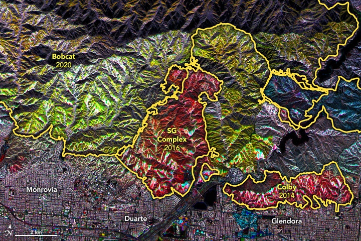
The map above is a mosaic of observations in the same area over a decade. Radar signals bounce off burned barren terrain differently than they reflect from unburned, vegetated ground. The colors indicate relative levels of vegetation, and yellow lines delineate several major fires. NASA Earth Observatory images by Joshua Stevens, using UAVSAR data and imagery courtesy of Anne Marie Peacock, Naiara Pinto, and Yunling Lou and NASA/Caltech UAVSAR.
The map shows the patchwork of plant ecosystems at different stages of development, with red at an earlier and green at a later stage. However, there have been cases of little to no forest regeneration, which has experts worried and seeking to understand why. A study by Dr. Stevens-Rumann of the Colorado State Forest and Rangeland Stewardship found correlations between geographical features, species and regrowth likelihood. For instance, chances of recovery are lower on steep slopes, or places with repeated blazes that reduce the ground’s seed bank.
The hills of California are gradually losing forest to brushy, dry vegetation that is itself highly flammable, thus creating a positive feedback loop. Trees are also more communal that one might expect, as proximity to living, mature trees is also a big factor in forest regrowth and gradual thinning chips away at forests’ ability to bounce back. Other factors such as water availability, arboreal diseases, species and altitude come together to influence ecosystem regeneration, all of which are detectable with satellite instruments.
Cross-referencing our theoretical understanding with observed patterns will help us determine the important factors with higher accuracy, and help with better forest management in the future.
This article was written by Owen Mulhern.
You might also like: Sea Level Rise Faster Than Previously Thought


![The Statistics of Biodiversity Loss [2020 WWF Report]](https://u4d2z7k9.rocketcdn.me/wp-content/uploads/2020/12/lprwinkyTHB-544x306.jpg)


